Map of Europe 1914: Countries, Borders and Empires Before World War I
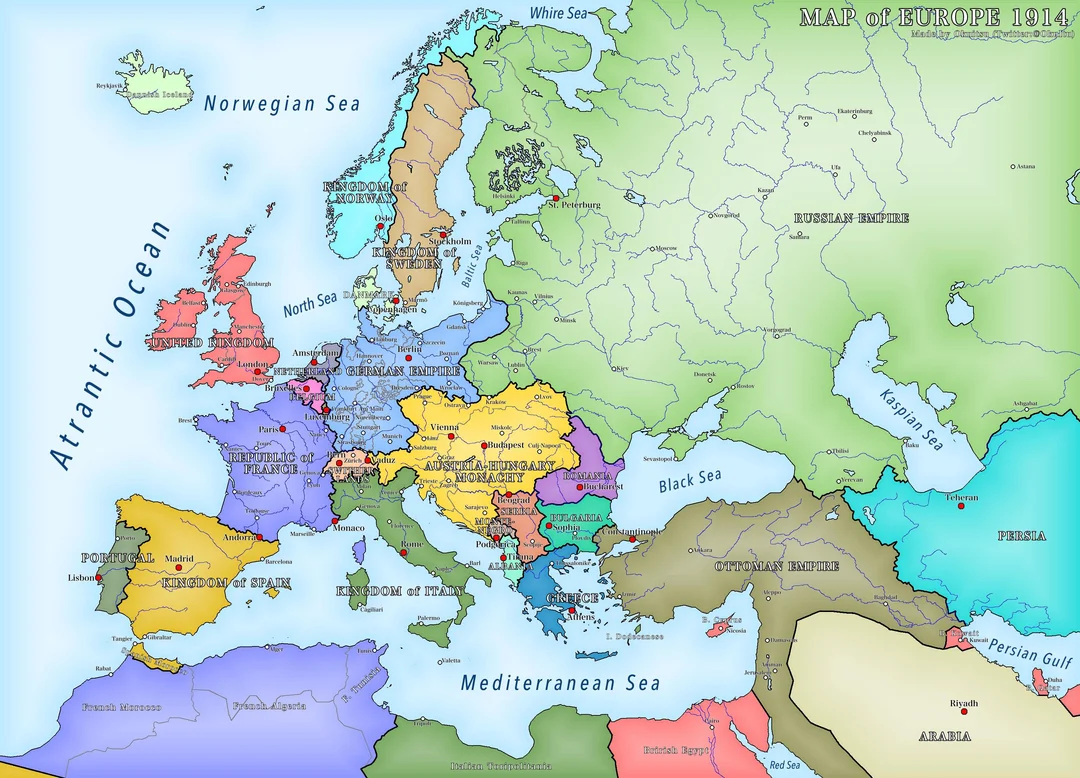
The map of Europe 1914 reveals a continent shaped by powerful monarchies, competing empires, territorial ambitions and diplomatic alliances. Before the First World War began, European borders looked remarkably different from those shown on modern maps. Germany, Austria-Hungary and Russia controlled extensive territories, while numerous smaller countries occupied strategically important positions. Understanding this historical geography helps readers explore the political relationships and international tensions that shaped Europe at the beginning of the twentieth century.
Studying the map of Europe 1914 also provides valuable insight into the origins of the First World War. Many European territories were governed by imperial dynasties rather than independent national governments, creating tensions between rulers and nationalist movements. Political alliances connected powerful nations, while disputes over borders and influence threatened regional stability. By examining historical boundaries, readers can understand how Europe’s political landscape contributed to the outbreak of a conflict that transformed countries, societies and international relations.
Countries and Political Boundaries in Europe in 1914
European borders in 1914 reflected centuries of territorial expansion, royal inheritance and political negotiation. France, Germany, Italy, Spain and Portugal existed as independent countries, alongside Belgium, the Netherlands, Switzerland and Luxembourg. The United Kingdom was also a major European power, supported by a powerful navy and an extensive overseas empire. Although some national boundaries remain recognisable today, many territories had different political arrangements and relationships with neighbouring states.
One striking feature of the map of Europe 1914 is the absence of an independent Poland. Polish territory had been divided between the German Empire, the Russian Empire and Austria-Hungary during earlier partitions. Finland existed as an autonomous Grand Duchy within the Russian Empire rather than an independent state. Ireland was part of the United Kingdom, while Bosnia and Herzegovina was under Austro-Hungarian rule. These examples demonstrate why historical maps must be interpreted in their political context instead of being compared with modern borders alone.
The Major Empires of Europe in 1914
The German Empire was one of Europe’s most powerful states in 1914. Established in 1871 under Prussian leadership, it developed into a major industrial and military power. Its growing economy, expanding navy and international ambitions contributed to competition with Britain, France and Russia. Germany’s position in Central Europe also made it strategically important, as its borders connected it with several countries whose governments had different security concerns and diplomatic objectives.
Austria-Hungary controlled extensive territories across Central Europe and the Balkans, bringing together numerous ethnic and linguistic communities under one dual monarchy. The Russian Empire extended across Eastern Europe and vast areas further east, while the Ottoman Empire retained territories in southeastern Europe. Britain and France maintained influential European positions alongside enormous overseas empires. The map of Europe 1914 illustrates how these major powers shaped the continent’s political balance and competed for influence before the outbreak of war.
European Countries and Regions Before World War I
Western Europe included France, Belgium, the Netherlands, Luxembourg and the United Kingdom. Their geographical positions influenced trade, diplomacy and military planning. Belgium was particularly important because it lay between France, Germany and the North Sea. Britain was separated from mainland Europe by the English Channel, but its naval strength and international connections allowed it to influence European affairs considerably. France’s border with Germany also became significant during the growing tensions before the war.
Central and Eastern Europe were dominated by Germany, Austria-Hungary and Russia, whose territories covered extensive areas. Northern Europe included Sweden, Norway and Denmark as separate states. In Southern Europe, Italy, Spain and Portugal occupied important Mediterranean and Iberian positions. The Balkans contained a complex mixture of independent countries and territories affected by imperial ambitions. Looking at the map of Europe 1914 through these regional divisions makes it easier to understand how geography influenced political relationships and military strategy.
European Alliances on the Eve of World War I
The alliance system was one of the defining features of European diplomacy before the First World War. Germany, Austria-Hungary and Italy belonged to the Triple Alliance, although their national interests were not identical. Italy remained neutral when fighting began in 1914 and eventually joined the Allied side in 1915. This distinction matters because alliance membership did not mean every country would automatically enter a conflict at the same time or follow precisely the same military objectives.
The Triple Entente connected Britain, France and Russia through diplomatic agreements and cooperation. These relationships developed partly because governments were concerned about rival powers and the changing balance of military strength. The alliances did not make war inevitable, but they helped widen the crisis that followed the assassination of Archduke Franz Ferdinand. When combined with the map of Europe 1914, these political relationships reveal how strategic geography and diplomatic commitments influenced the decisions made during the summer of 1914.
The Balkans and Rising Political Tensions
The Balkans were among the most unstable regions in Europe before the First World War. The weakening Ottoman presence, competing national movements and territorial ambitions created repeated disputes between neighbouring countries. Serbia sought greater influence for South Slavic peoples, while Austria-Hungary feared that Serbian nationalism could encourage unrest among communities living inside its own borders. These opposing ambitions made southeastern Europe a particularly sensitive region for European diplomacy.
Austria-Hungary formally annexed Bosnia and Herzegovina in 1908, increasing resentment among Serbian nationalists. On 28 June 1914, Archduke Franz Ferdinand, heir to the Austro-Hungarian throne, was assassinated in Sarajevo. The event triggered a diplomatic crisis that rapidly escalated. Austria-Hungary declared war on Serbia in July, and mobilisation plans and alliances helped expand the conflict. The map of Europe 1914 therefore provides essential geographical context for understanding why tensions in the Balkans became the starting point of a much wider war.
How Europe’s Map Changed After the First World War
The First World War transformed Europe’s political geography. The German, Austro-Hungarian, Russian and Ottoman empires experienced collapse, revolution or major territorial losses. The end of these imperial systems changed the balance of power and created opportunities for national movements to establish independent countries. Peace negotiations, territorial adjustments and political upheaval reshaped large areas of Central and Eastern Europe during the years following the conflict.
Poland regained independence, while Finland and the Baltic states of Estonia, Latvia and Lithuania emerged as independent countries. Czechoslovakia was established, and the Kingdom of Serbs, Croats and Slovenes formed in the southern Slavic territories, later becoming Yugoslavia. Austria and Hungary became separate states. Comparing the map of Europe 1914 with maps from the post-war period highlights these changes and shows how the collapse of empires created a new political landscape across the continent.
Map of Europe 1914 Compared with Modern Europe
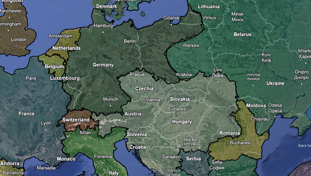
Comparing historical and contemporary European maps reveals how much national boundaries have changed over time. Germany’s imperial territory differed from its present-day borders, while Austria-Hungary no longer exists as a single state. Regions once governed by large empires now belong to several independent countries. These changes reflect the effects of warfare, peace treaties, independence movements and political decisions made throughout the twentieth century.
The map of Europe 1914 also provides a useful starting point for understanding later developments, including the dissolution of the Soviet Union and Yugoslavia. Germany experienced division after the Second World War before reunification in 1990, while several countries in Central and Eastern Europe regained independence or changed political systems. Examining these developments alongside historical boundaries helps readers distinguish between different periods and understand how Europe’s present-day geography evolved through a series of major historical events.
Where to Find a Reliable Map of Europe in 1914
Readers searching for a map of Europe 1914 can explore historical archives, educational websites, digital libraries and printed atlases. Wikimedia Commons provides access to historical images, while World History Encyclopedia offers educational resources that help explain the political background of different periods. University libraries and digitised historical collections can also be useful for locating detailed maps suitable for research, school assignments and educational articles.
Before using a map, check its publication date, source, labels and copyright conditions. Some maps show Europe immediately before the war, while others represent the situation after mobilisation or during later stages of the conflict. Choose a high-resolution image when precise borders and place names matter. If publishing the image online, provide an accurate caption and descriptive alternative text so readers can understand its historical significance and search engines can interpret the page’s subject more effectively.
Why the Map of Europe in 1914 Still Matters
Historical maps help explain how political decisions, geographical positions and national identities influence international relations. The map of Europe 1914 shows how imperial control and competing ambitions shaped the relationships between European powers. It also demonstrates why certain territories became the focus of diplomatic disputes and military planning. Understanding these details makes historical events easier to follow because readers can connect political developments with the places where they occurred.
For students, historians and general readers, historical geography offers a clearer understanding of the First World War and its consequences. It explains the disappearance of major empires, the emergence of new countries and the continuing importance of national identity. Comparing old maps with contemporary geography also encourages a deeper appreciation of how borders change. Rather than viewing Europe as a continent with fixed boundaries, readers can recognise it as a region whose political landscape has repeatedly evolved through conflict, diplomacy and cooperation.
Conclusion
The map of Europe 1914 captures a continent dominated by powerful empires, complicated alliances and political boundaries that differed considerably from those seen today. Germany, Austria-Hungary, Russia and the Ottoman Empire controlled extensive territories, while smaller countries and nationalist movements influenced regional politics. These arrangements formed the background to the tensions that eventually developed into the First World War.
Exploring the map of Europe 1914 helps readers understand the origins of the conflict and the extraordinary changes that followed. The collapse of empires, the restoration of Poland and the emergence of new states transformed Europe’s political geography. By comparing historical borders with modern ones, students and history enthusiasts can gain a clearer understanding of how warfare, diplomacy and national identity shaped the continent.
FAQs
What did Europe look like in 1914?
Europe contained independent countries alongside large empires, including Germany, Austria-Hungary, Russia and the Ottoman Empire.
Which major empires existed in Europe in 1914?
The German, Austro-Hungarian, Russian, Ottoman and British empires were among the major imperial powers.
Why was Poland missing from the map in 1914?
Poland was not an independent state because its territory had been divided between Germany, Russia and Austria-Hungary.
How did Europe’s borders change after the First World War?
Several empires collapsed, Poland regained independence, and new countries emerged from former imperial territories.
Where can I find a historical map of Europe in 1914?
Wikimedia Commons, World History Encyclopedia, historical atlases and digital library collections are useful places to begin searching.